FIRE ECOLOGIES
AND COSMOLOGIES
Fire, Wildfire, Megafire: Ecologies of Fire
Jennifer Gabrys—Smart Forests
Wildfires are a recurring and often integral part of how landscapes rejuvenate. With climate change, increasing temperatures and aridification, however, wildfires are becoming even more extensive and severe, affecting landscapes that might not have been typically subject to fires. During 2024, South America experienced some of the largest fires on record, with over 85 million hectares burned across eight countries. These fires included the Pantanal wetlands in Brazil, which burned 440,000 hectares, and 162 forest fires in Chile, where high temperatures and a mega-drought created highly flammable conditions. At the peak of this South American fire event, the Global Wildfire Information System remotely sensed thousands and hundreds of thousands of fire hotspots, creating record carbon emissions.Copernicus Atmosphere Monitoring Services (CAMS), CAMS Global Wildfires Review 2024.
From the chaparral and oak savanna ecosystems of California to the boreal Northern forests, the Amazonian forests and cerrado of South America, fires are becoming higher intensity and more destructive. The fires in Los Angeles, USA, erupted across several weeks in January 2025 and destroyed over 23,000 hectares of land. Among the most severe in the area’s history, the wildfires scorched buildings and infrastructure in fast-moving walls of fire that flattened entire neighborhoods.McCarthy and Richter, “4 Graphics Explain Los Angeles’ Rare and Devastating January Fires.” Since the beginning of 2025, nearly 1 million hectares of land have burned across Europe, resulting in 1,923 fires and emitting 39.4 Mt of CO2. This is more than double the average burned area in Europe from 2006–2024.Joint Research Centre, “Current Wildfire Situation in Europe.” Elsewhere, the Canadian boreal forests burned 15 million hectares in 2023 and over 3 million hectares in 2024. Meanwhile, Australian bushfires have burned over 140 million hectares across 2023–24, following on from intense wildfires in previous years. According to fire ecologist Andrés Fuentes Ramirez and co-authors, “An increasing number of forest fires take place worldwide, with an estimation of 350 million hectares burned annually.”Arroyo-Vargas et al., “Impacts of Fire Severity.”
Fire can reshape ecologies.Gabrys, “Sensing a Planet on Fire.” Megafires, in particular, are remaking ecologies worldwide.Petryna, “Wildfires at the Edges of Science”; Anthes, “How Megafires are Remaking the World.”They are contributing to the transformation of flora and fauna, the release of carbon emissions, and environmental tipping points that can contribute to even more uncertain conditions. Fire is becoming more destructive. With accelerating climate change, including temperature rises, extreme weather patterns, and aridification and desertification, fires of greater intensity are more likely to occur.MacCarthy et al., “The Latest Data Confirms: Forest Fires Are Getting Worse.” At the same time, land-use patterns continue to complexify and generate more fire-prone conditions due to sprawling development, wildland-urban interfaces, and fuel accumulation.

Fire is an element of change and of relation. It sparks transformations and creates conditions for its continuation, from vegetation and atmospheric conditions to organisms such as humans becoming fire makers. Stephen Pyne uses the term “Pyrocene” to work through the long and sudden histories of how humans have used fire to reshape the planet. However, Pyne suggests that fire has also used humans as fire bearers and amplifiers. Fire makes and sustains fire worlds, where fire and life co-evolve.Pyne, The Pyrocene. In these conditions, fire can also be an agent of destruction, not only razing settlements and landscapes but also generating transformed ecologies and “fire weather” in the form of pyrocumulonimbus events, distinct weather systems that include fire tornadoes, cloud formation, and atmospheric dynamics that can propagate ever-more intense fire conditions.Vaillant, Fire Weather.
Fire in Chile is similarly caught within a mutable, flickering relation to planetary upheaval. Unlike California, Chilean landscapes have not depended historically upon fire for germination or regeneration, and the vast majority of fires are human-generated.Úbeda and Sarricolea, “Wildfires in Chile.” However, Chilean landscapes have adapted in some circumstances to fire sparked from lightning, volcanic activity, and human land practices that have reshaped environments to favor hunting, agriculture, and eventually forestry and development.Otero, Huella del Fuego. Recent fires in Chile are growing in scope and intensity, often caused by intentional or accidental human activity within increasingly climate-stressed areas with complex and often unsustainable land-use patterns. Fires in Viña del Mar in 2024 were one of the deadliest disasters in Chile’s history, leading President Gabriel Boric to declare a state of emergency.Martínez, et al., «Informe de daños». Previous blazes at China Muerta in La Araucanía region of Chile in 2015 remain scarred from the severity of the fire, accidentally set by a bonfire not fully extinguished that led to the destruction of over 6,000 hectares of land, including 3,765 hectares of Araucaria-Nothofagus forests that are endemic to this region.Fuentes-Ramirez et al., “Spatio-Temporal Variation in Soil Nutrients and Plant Recovery.”
Because of the increasing intensity of fires in Chilean, South American and global landscapes, we initiated this Ecologies of Fire project, collaboration and collection as a transdisciplinary investigation into changing fire regimes in Chile. Emerging from a collaboration between the Smart Forests research project at the University of Cambridge and the Fundación Mar Adentro (FMA), the collaboration focuses on the Araucanía region in the Central South of Chile where FMA’s conservation area, Bosque Pehuén, is located. This 896-hectare conservation area in the Palguín basin is characterized by temperate rainforest ecosystems, and includes an exceptional array of flora and fauna, including the araucaria trees that are unique to this region. Looming to the west of the conservation area is the Villarrica National Park, which includes the Villarrica Volcano (Rucapillán in Mapudungun), one of the most active volcanoes in South America. To the southeast of the site is the Quetrupillán Volcano, an inactive volcano within the Andes Cordillera, which is otherwise characterized by intense geological activity.

We initiated the Ecologies of Fire collaboration in May 2023, undertaking research through meetings, site visits, interviews, and network building with fire experts and practitioners. From November 2023 onwards, we collaborated on the formation of an art and science residency at Bosque Pehuén, with five selected residents, Bárbara Acevedo Strange, Fernanda López Quilodrán, Gianna Salamanca, Pamela Iglesias, and Valeria Palma, spending 5 weeks at Bosque Pehuén from March to April 2024 to work on topics of fire in the Chilean landscape and beyond.Short videos of each resident’s projects can be found on the Fundación Mar Adentro YouTube channel within the “Residencia Bosque Pehuén 2024: Ecologías de fuego” series, including Bárbara Acevedo Strange, https://www.youtube.com/watch?v=yvZ7FEx4HxA; Fernanda López Quilodrán, https://www.youtube.com/watch?v=YrMis52L9W4; Gianna Salamanca, https://www.youtube.com/watch?v=85wEsRzy5-0; Pamela Iglesias, https://www.youtube.com/watch?v=rTzKv_zZnwo; and Valeria Palma, https://www.youtube.com/watch?v=TTI_59W0IMw. As discussed in more detail in the next chapter, the residents developed compelling investigations into the biocultural dimensions of fire, visualizations of oxidation processes, records of different tree species and flammability, and Indigenous approaches to fire and forest ecosystems. These transdisciplinary initiatives opened a space for expanded dialogues about the multiple dimensions of fire.Errázuriz et al., “Fire Ecologies.”
The residency program became a central forum for asking how cultural fire practices interact with landscapes, and how they could or should be reshaped. Engagements with fire can vary across disciplines and practices, and we considered how the arts, design, architecture, media, literature, history, anthropology, natural sciences, planning and policy, grapple with the force and effects of fire in changing environments. In addition to travelling across disciplines, we observed how understandings of fire differ across organisms and scales, where fire from the perspective of a plant can give rise to investigations into flammability, while a cultural or societal view of fire can generate attention to collective networks and practices for managing fire, and a wider landscape view can show how fire patterns are changing over time.
Fire is a biocultural agent, territorial inheritance, ceremony, sustainer, destroyer, and transformer. To engage with pluralistic fire practices and site-related knowledges, we held two Field Schools in April 2024, one at the Bosque Pehuén reserve with the residents that explored fire stories and practices on site, and the other at Universidad de la Frontera in Temuco, where we met with stakeholders from CONAF (The National Forestry Corporation), community fire prevention networks, academic researchers, and multiple other actors working on fire topics. We documented and reflected upon these Field School sessions on our Smart Forests Atlas, outlining methods and key findings.Tiara Torres et al., “Fire Ecologies”; Tiara Torres et al., “Community Fire Plans.” Building on these first stages of the project, we then undertook a wide range of interviews and site visits with communities, researchers, and policymakers working on fire topics across regions including La Araucanía, Los Ríos, Bío-Bío, Nuble, Valparaíso, and Metropolitana. What we found is that transdisciplinary, ancestral, and collective fire practices can spark different ways of inhabiting the land.
We published a selection of these conversations on our Smart Forests Radio as podcasts for wider listening.Smart Forests Radio, “Forest Fires.” We then held a third Field School in Pucón to focus more specifically on which networks, technologies, and practices could be most beneficial for community members to adopt when addressing fire events. Our event involved presentations, collective mapping, and speculating about fire conditions and relations, including with a fire game from one of the artists-in-residence, Bárbara Acevedo Strange. Her project, included in this collection (pp. 203–209), works across gesture, figure and speculative events to conjure different fire relations and possibilities. This final Field School is also documented on our Smart Forests Atlas,Tiara Torres et al., “Exchange of Community Experiences.” together with a film and report documenting findings from this research in the context of the larger Smart Forests project.Mind the Film with Smart Forests. Smart Forests film.
Local knowledge, cultural memory, ancestral fire practices, fire stories and stories of the land infused our collective discussions across our many meetings, events, and exchanges, into how fire influences land relations, research, and practices. In this sense, this collection shows how cultures of fire are central for considering different meanings and relationships to fire. Even at the level of language and translation, we found that different types of fire and cultural practices could be opened up when working across Spanish and English. Fuego, incendio, megaincendio—or fire, wildfire, and megafire—were three terms that launched us into an ongoing discussion about types of fire, their connections and effects, the distinct techniques and technologies involved in igniting and monitoring fires, and the practices that could arise to craft collective engagements with fire. Fuego, incendio, megaincendio are three words that allow us to consider fire histories by participating in fire research, practice and collective debates, as well as reading signs in the landscape and considering the social and cultural aspects of fire.
The chapters that follow are written as collective conversations with participants and interviewees. They include key themes that arose from our collaboration, including cosmologies and cultures of fire, as well as fire networks, technologies, and practices. Interwoven with chapters on each of these topics is work from the Ecologies of Fire residents, along with interviews with stakeholders working on topics related to fire. We end this collection with a conclusion that is more of an opening in the form of fire proposals, which synthesize our collective learning into a more distilled yet ongoing guide for how to address fire in a time of digitalization and planetary upheaval.
Fire networks
Social organization can take shape through environmental forces and events, as the many disasters in the Chilean landscape have demonstrated. Within Chile, there are agencies, scenarios, models, and social networks for responding to earthquakes, tsunamis, and volcanoes, all significant and distinctive features of the landscape. Fire as an environmental agent is somewhat less established than these forces within community infrastructures. However, due to changing climates and environments, it is becoming a more prominent agent within emerging forms of social organization. Fire is not only a disaster but also is becoming part of landscape processes in ways that differ from usual disaster responses, since it can become part of ongoing territorial networks, relations, and governance.
The Ecologies of Fire collaboration explored how social organization takes shape in relation to fire events. From community fire prevention manuals developed by the National Forestry Corporation (La Corporación Nacional Forestal / CONAF) to community fire infrastructures at the Altos de Cantillana reserve, we learned about a diverse range of social networks that are materializing in response to fire events. The “Fire Networks” chapter that follows, discusses in more detail our explorations, conversations, and findings to document and analyze this important component of social-ecological relations, and to inform our proposals and findings in the concluding chapter.
Fire technologies
The Smart Forests research project investigates the increasing digitalization of forest environments amid planetary change. It asks how forests are becoming digital environments and what the social and political effects of these changes could be. Fire is one of these areas of increasing technologization, where practices of monitoring, combatting, and preventing wildfires are often undertaken with the aid of digital tools. From remote sensing for detecting at-risk areas for fire events, to AI analytics to inform real-time alerts, community-focused apps, and geospatial tools for recovering after fire events, there is an increasing number and range of digital tools and infrastructures for monitoring and responding to fires.Wonder Labs, The State of FireTech Annual Update.As part of this Ecologies of Fire collaborative investigation, we looked specifically at how digital technologies contribute to remaking fire networks, tools, and practices.
Fire practices
Our research and collaboration especially have focused on fire practices, from community plans to educational programs, preparedness committees, and site-specific forms of governance that are emerging to address fires. We found many instances of community-led initiatives that often involve practices for preventing and responding to fires, with some attention also given to restoration after fires have taken place. CONAF has developed a fire prevention methodology for communities to adopt, to harmonize techniques across many different regions of Chile.
At the same time, we found many opportunities for communities to join up, learn from one another about different fire practices, create educational programs, connect with resource and research institutes, create plurinational forms of mapping and planning, and advance collective environmental action at a time of unprecedented planetary transformation. In some cases, fire practices incorporate technologies, including digital tools and infrastructures, to coordinate and analyze fire plans and events. In other cases, digital technologies are remote from community-led practices, which rely more on analogue techniques and community organizing. As our conclusion suggests, there are opportunities to connect fire practices, for communities to exchange knowledge and create shared resources, and to advance educational and cultural engagements with fire that are sensitive to the different approaches to fire and land management.
Fire proposals
Our conclusion takes the form of proposals for living with fire. We offer a conceptual and practical focus on fires that attends to changing environments and the new tools and techniques, as well as modes of social organization and cultural engagement that help navigate these changing sensory ecologies. Working from within this transdisciplinary approach, which brings art, culture, Indigenous and local knowledge, sociology, environmental science, and digital technology, we seek to contribute to understandings of fire that are at once technical and poetic.
This collection suggests that with changing fire regimes, it is necessary to change relations to fire. This requires taking a more holistic approach that moves away from combatting or suppressing fire to changing the way we think about fire as an integrated social, cultural, ecological, and technological system. We suggest that this pluralism of fire ecologies can broaden and expand understandings of fire, while also creating enhanced tools for social organization and environmental action.

Cosmologies and Cultures of Fire in La Araucanía
Maya Errázuriz, Tomás Altamirano,
Felipe Guarda and Sebastián Carrasco
—Fundación Mar Adentro
The unique combination of oxygen, fuel, and heat on Earth is what allows fire to exist, and as far as we know, this is the only planet where flames can burn. The origin of the Spanish word fuego (fire) comes from the Latin focus, which refers to the place where a fire is lit for cooking and heating a home. In its adaptation to Spanish, fuego gives rise to the word hogar (home), linking fire not only to combustion but also to the idea of home. Fire brings people, knowledge, rituals and traditions together; there is life, healing, alchemy, curiosity to learn and a genuine reception of energy. However, there is also destruction, death, scars and transformation, especially in the context of global environmental change.
In Wallmapu (territory), the Mapuche worldview teaches that the spirit of the kütral (fire in Mapudungun) is called choñoiwe and resides in the hearth. It carries messages from people on Earth to the Wenumapu (the sky) through smoke, and for this reason, an offering must always be made to the fire. This spirit is divided into two energies, choñoiwe füsha (masculine) and choñoiwe küshe (feminine) or “old woman fire,” who is the companion of the Mapuche woman. It is said that she is the one who called Lalen Kuze, the spider who taught weaving in the epew (story) about the origin of weaving.Text adapted based on information provided by Ana Millaqueo, intercultural educator, during a training session on fire held on 30 July 2025 at Bosque Pehuén, Chile. Fire, in this territory, is an element that enables life and sustains fundamental rituals. Within this territorial epistemology of fire, we propose broadening our perspectives on ecology and conservation beyond the usual scientific prism.
Fire stories in La Araucanía
La Araucanía region, in southern Chile, stretches between 37°35' and 39°37' south latitude, from the high peaks of the Andes mountain range to the Pacific Ocean. Its vegetation thrives in a temperate, rainy climate with annual rainfall reaching 1,250 mm, concentrated in the winter months. In the Andean Araucanía, the climate is predominantly cold at high altitudes with increased precipitation (in the form of rain and snow), and temperatures below 0°C during the winter.AGRIMED, Atlas Agroclimatico de Chile.
The region's climate, geomorphology, and volcanic soils support abundant natural vegetation characterized by the presence of diverse vegetational formations, from deciduous forests in valleys with a Mediterranean influence (forests of Nothofagus obliqua and Crytocarya alba) to abundant temperate rainforests and coniferous forests dominated by the emblematic Araucaria araucana.Luebert Bruron and Pliscoff, Sinopsis bioclimática y vegetacional de Chile.
The history of fire in La Araucanía and its close relationship with vegetation are strongly marked by the transition from natural regimes and ancestral fire management to high-severity, extensive fires driven by human action and by profound changes in the landscape.Otero, La huella del fuego; González et al., «Cambio climático y su impacto potencial». On a broad temporal scale, fire was a key natural disturbance in the ecology of southern Chilean ecosystems, acting as a driver of change in temperate forests, araucaria forests, and scrublands.Veblen et al., “Fire History in Northern Patagonia.” Mapuche communities used fire in a controlled manner for agricultural purposes, with landscape management shaped by a low-intensity fire regime. “Forest clearing agriculture” was practiced in the low ridges and foothills, taking advantage of the fertility of forest soils and their rapid resilience after fires.Otero, La huella del fuego; Cárdenas et al., Los Chonos y los Veliche de Chiloé. However, during the 19th and 20th centuries, with colonization and the advance of the agricultural frontier in Chile, the use of fire began intensified to convert forests into land suitable for livestock and agriculture, leading to widespread deforestation and large-scale fires. In the 20th century, and particularly after the 1970s, the expansion of monoculture plantations of exotic species (Pinus spp. and Eucalyptus spp.) has significantly altered the structure, composition, and functions of the landscapes in this region, increasing fuel continuity and susceptibility to fire.Castillo et al. 2020.
In recent decades, the combination of socio-ecological processes such as climate change, biological invasions, rural abandonment, biomass accumulation, and the growth of the urban-rural interface in La Araucanía have contributed to a considerable increase in the frequency, extent, and severity of fires, with increasingly extreme events posing a growing threat to the region's ecosystems and local communities.Úbeda and Sarricolea, “Wildfires in Chile.” According to data published by the National Forestry Corporation (CONAF),More information and details on this data can be found at: https://www.conaf.cl/incendios/situacion-actual-y-pronostico-de-incendios. between 2023 and 2025, the number of fires in the region exceeded 1300 incidents, with an affected area of 60150 hectares in the 2024 - 2025 season alone.
In the current context of global change, fire management in La Araucanía faces significant challenges, including integrating scientific, traditional, and local knowledge and practices for the development of community fire prevention and management strategies.


Natural laboratory for a transdisciplinary conservation plan
Since 2006, our foundation has promoted the Bosque Pehuén Natural Laboratory, a space for integrating knowledge about temperate forests of the Andean Araucanía. Formerly exploited in the 1970s for timber, these approximately 900 hectares now provide a biological corridor for the Villarrica National Park and a refuge for many endemic species in the locality of Palguín Alto, within the municipality of Pucón.
As part of the stewardship efforts of this area, and in line with open conservation standards, over the last two years, we have held participatory workshops with researchers, local residents and public institutions to define priority actions for managing the area, including key conservation values and the threats they face. One of the most significant threats identified was forest fires. Unlike other threats that can be managed within the area’s boundaries, this threat presents particular challenges, as a fire can spread from outside the area and originate from multiple causes. No matter how prepared a conservation area may be internally, what happens in surrounding areas is beyond the control of those who manage it. Hence, it is a threat that must be addressed in a community-based, relational manner, drawing on diverse knowledge bases and perspectives.
It is becoming increasingly clear that fires are one of the greatest sources of disturbance in natural ecosystems,Bond and Wilgen, Fire and Plants; Roces-Díaz et al., “A Global Synthesis of Fire Effects.” with highly heterogeneous effects on landscapes.Kobziar et al., “Principles of Fire Ecology.” The ecological effects of fire on forests can be seen in the microclimate (e.g., changes in humidity and temperature), in soil (e.g., loss of nutrients and organic matter), in biodiversity (e.g., alterations in the composition and structure of plants)Hernández et al., Biodiversidad. and ecosystem services (e.g., water quality, erosion control, and climate regulation).Roces-Díaz et al., “A Global Synthesis of Fire Effects.”
The world's temperate forests are located between the tropical forests and the polar circles of both hemispheres, and are characterized by strong seasonality, extreme temperatures, and, in some cases, natural fire regimes that contribute to their regeneration and structural diversity.FAO, “Global Ecological Zones for FAO Forest Reporting”; Bond and Keeley, “Fire as a Global ‘Herbivore.’” These forests exhibit heterogeneity in fire frequency, intensity, and extent, creating ecological mosaics that maintain biodiversity and landscape structure.Pausas and Keeley, “A Burning Story.” Thus, fire regimes are dynamic and respond to interannual climatic factors such as rainfall, prolonged droughts, oceanic oscillations, and large-scale changes such as climate change.Bowman et al., “Fire in the Earth System.” Therefore, vegetation dynamics, climatic conditions, and anthropogenic disturbances have historically shaped the fire ecologies of these forests. Thus, depending on the context and severity of the fire, fire is not only a threat but also an ecological process that regulates species regeneration, nutrient availability, and habitat connectivity in these forests.Certini, “Effects of Fire on Properties of Forest Soils”; Pausas and Keeley, “A Burning Story”; McLauchlan et al., “Fire as a Fundamental Ecological Process.”
However, today these fire ecologies in temperate forests are being transformed and accelerated by climate change and increased anthropogenic activity.Flannigan et al., “Implications of Changing Climate”; McLauchlan et al., “Fire as a Fundamental Ecological Process.” High temperatures and drought have intensified the frequency and severity of fires, altering historical regimes and exceeding the adaptive capacity of many species and ecosystems.Moritz et al., “Learning to Coexist with Wildfire.” These new conditions pose several challenges. On the one hand, we need to understand the ecological thresholds that maintain the forests' resilience to fire and, at the same time, design adaptive management strategies that integrate ecological knowledge with prevention and restoration practices.Lindenmayer et al., “Newly Discovered Landscape Traps.”
Currently, research on fire ecologies in temperate forests recognizes fire as an essential agent of forest dynamics, but also as a phenomenon amplified by climate change that requires new interdisciplinary and transdisciplinary approaches.

Installation by Gianna Salamanca presented in the public residency program Bosque Pehuén - Ecologies of Fire at Casa Varas, a cultural center in Temuco, La Araucanía, April 2024. During her research, she collected various charcoal samples in Bosque Pehuén. Marcos Maldonado.

Part of the installations by Fernanda López de Quilodrán (left) and Valeria Palma (right) for the public residency program Bosque Pehuén – Ecologies of Fire presented at Casa Varas, a cultural center in Temuco, La Araucanía, April 2024. On the left, a suit that Fernanda wore in the forest to measure CO2 emissions; on the right, a video of Valeria measuring the ignition of native trees. Marcos Maldonado.
Community and artistic approaches to forest fire prevention
Our need to advance towards a deeper understanding of the current state of community forest fire prevention in the territory where Bosque Pehuén is located led to our collaboration with Smart Forests, whose socio-political and cultural approach, viewed from the effects of the technologization of forests to understand, monitor and manage them, resonated with the research we seek to promote as a foundation.
This collaboration allowed us to gather knowledge and experience from different regions of the country, including Valparaíso, Bio-Bío, Metropolitana and La Araucanía regions (which have been “emblematic” for forest fires in recent times). The forms of knowledge were also diverse, drawing not only on professional or academic perspectives about the phenomenon of fires and their control, but also on the institutional perspectives of public agencies that must coordinate control and mitigation efforts on a daily basis, the localized knowledge of community organizations that develop plans for their localities, and even the practices carried out in the territory near Bosque Pehuén.
Additionally, since 2016, we have been promoting a residency program with artists in Bosque Pehuén that offers a sensory and speculative approach to the study of temperate forests, generating more comprehensive processes for the management of this conservation area. Each year, this forest welcomes groups of researchers from various artistic and social/natural science disciplines to promote a critical and conscious view of our relationship with nature. For its 11th cycle (Ecologías de Fuego), the program addressed fire as a way of integrating its methodologies with the collaboration and research processes carried out with Smart Forests.
Seeking to amplify and generate greater crossovers across disciplines, the program welcomed proposals from five artists and researchers (Bárbara Acevedo Strange, Pamela Iglesias, Fernanda López Quilodrán, Gianna Salamanca, and Valeria Palma), who approached fire and its relationship with forests from multiple social-ecological and cultural dimensions. Through an exchange of knowledge, experiences, field activities, and the study of archives and images, they carried out a sensitive and collective investigation into the diverse epistemologies of fire, its interrelationships with climate change, implications and/or resonances with regard to gender and interculturality, and meanings according to various worldviews present in the territory.The results of this residency were presented in a public program on 16 April 2024 at Casa Varas, a self-managed cultural center in the city of Temuco, in the Araucanía region.
In this book, their approaches offer multiple perspectives on fire. Gianna Salamanca’s writings open up perspectives on biocultural notions of fire and introduce us to stories and histories of charcoal and its relationship with insects, fungi, and forest soils. Bárbara Acevedo Strange presents The Forest Fire as a Planetarium: A Prophetic Game, a series of visual narrative tools for constructing post-apocalyptic worlds. Pamela Iglesias, on the other hand, introduces an intercultural perspective, creating a video-performance work entitled Intermediate disturbance, which takes as its starting point the Mapuche myth of Lalen Kuze (ancient spider).

Gianna Salamanca comparing geospatial views of La Araucanía during the Ecologies of Fire residency, Bosque Pehuén. Maya Errázuriz, 2024.
Fernanda López Quilodrán, in turn, approaches the study of fire through bodily movement and a reading of carbon emissions with a suit that combines art and electronics. From a scientific perspective, Valeria Palma studies the flammability of five species present in Bosque Pehuén: Araucaria araucana (monkey puzzle tree; araucaria), Laureliopsis philippiana (tepa), Nothofagus alpina (raulí beech), Nothofagus dombeyi (evergreen beech; coihue), and Saxegothaea conspicua (Prince Albert’s yew; female mañío), with graphs that demonstrate relevant results for understanding the interaction between species when a fire spreads in these forests.
These different practices, together with the field school processes that we have carried out throughout this collaboration, have been fundamental to better understanding forest fire management, especially in terms of localized community organization. This transdisciplinary and participatory research has led us to continue organizing meetings with various residents, including in the Palguín basin, to co-design and co-construct a community forest fire prevention plan.
With this book, we hope to deliver not only the results of these processes but also an integration of knowledge about fires and their ecological and cultural role for a greater understanding of and preparedness for forest fires. May there be no shortage of water or flooding, may the air keep the environment clean, and may the fire of the sun continue to give life: Müñal ta Txawüluwi ta Meli Newen, fey ta mülekey ta Mogen, that is, only when the four energies come together or converge does life exist.Statement by researcher and historian Juan Ñanculef Huaiquinao in his book Tayiñ Mapuche kimün: Epistemología Mapuche, sabiduría y conocimientos.

Stories and Historicities
of Charcoal
and Other Creatures
Gianna Salamanca
Fire exists in a mosaic of typologies, some with more tempestuousness and drive than others. In its human-centered dimension, it has been said that only our species is born and evolves with fire. However, a wide spectrum of hominids and other creatures have interacted with it. Even so, it is unquestionable that our species is the only one that has learned to create it at will, thus sparking speculation about the end of the Holocene and the conceptual emergence of a “Pyrocene” (Diagram 1).An emerging concept in environmental humanities that refers, on the one hand, to the structural role of fire in contemporary geological configuration (“Pyrocene”) and, on the other, to the intensive use of fossil fuels and their impact on climate change (“petrofossil civilization”). See Pyne, The Pyrocene.

With the power of a petro-fossil civilization,Barboza Lizano, «Calentamiento global». the concept of “fire” carries with it a destructive impulse that seems to enable it with a biogeographical authority over other natural phenomena. In principle, this is the stripping away of its elemental status as a physicochemical force and as an entity with sufficient capacity to self-govern its own climatological patterns. Favorable atmospheric conditions that include aridification and warm winds of more than 30 km per hour can contribute to the proliferation of fire. This is to accept that, given the probability of ignition, fire can be rekindled by human forces, as well as more-than-human or natural forces. This complicates the reconstruction of its history over time.
In these notes, we speculate about fire’s origins. We delve into dense forests and ancient species, whose presence was captivating enough to be inscribed in the botanical imagination of Victorian gardens during the emancipation of the colonies. Drawing on science fiction and the observation of fleeting materials, we evoke geo-mythical and post-humanist botanical theories.These approaches are part of posthumanist and cosmopolitical discussions that propose an ontological democratization, where human and non-human entities—organisms, landscapes, materials, and forces—participate in the configuration of multiple modes of existence, questioning the notion of "the natural" as a unitary category and proposing to understand the cosmos as a plural space of relationships in negotiation. See Braidotti, Lo posthumano; Braidotti and Hlavajova, Posthuman glossary; and Stengers, Cosmopolitics I. We are committed to charcoal as a way of articulating the lives of other species, their individualities intertwined with capricious characters and a pluriverse that, beneath the roots, reveals a world of unicellular cartographies. Rooted in volcanic and forest soils, different kingdoms and their creatures will remain dormant for an indefinite period of time, waiting to begin their growth. However, some will have to fight against the challenge of never sprouting again.
Device I: The memory of charcoal

Object 1. Araucaria bark (Araucaria araucana) exposed to carbonization processes found in the China Muerta National Reserve, 2024.
Commonly, after a forest fire, the area where vegetation has been destroyed shows traces of charcoal. It is natural to think that all plant matter was consumed, but it is not the flames themselves that disrupt the architecture of an ecosystem, but rather the heat produced within them. In phytosanitary terms, a tree or the wood that supports it contains two organic compounds in its structure: cellulose and lignin. In cellulose, the carbon atoms are arranged in straight lines, while in lignin, the atoms are organized in rings, making it a highly aromatic compound. Together, these compounds give a tree's system degrees of hardness and resistance, establishing a relationship with its longevity on Earth and with the levels of interconnection among of the realms of nature.

Object 2. Charred coihue (Nothofagus dombeyi) from Bosque Pehuén, 2024.
As temperatures rise during a forest fire, ecosystems and their biological diversity are exposed to a series of physical and chemical reactions, leading to their decomposition. For some tree species, temperatures between 20 and 110° C are enough to expel water from their life systems, and at 270° C, their organisms could be completely dried out. At this stage, gases such as carbon monoxide (CO), carbon dioxide (CO2), methane (CH4), acetic acid (CH3COOH), and methanol (CH3OH) begin to be released. From 270 to 290° C, the material still has the capacity to absorb heat, producing some tar, a black mixture of liquid hydrocarbons and free carbon. Above 290° C, some exothermic reactions emerge, further increasing the temperature. This is the threshold that marks the onset of charcoal formation in a process called pyrolysis (Sample 1). Only above 400° C is the charcoal formation process complete, maintaining its cellular integrity as a solid material above temperatures of 1000° C. In summary, we recognize four successive phases: dehydration, torrefaction, pyrolysis, and advanced charring.Advanced charring corresponds to the final phase of the thermochemical decomposition of woody material, which occurs at temperatures above 700° C and can culminate in its reduction to ashes. In archaeobotanical contexts, this phase defines the threshold beyond which the preservation of charred plant material is compromised. If combustion stops at torrefaction, the fruits and seeds retain their external morphology, increasing the likelihood of their botanical identification.Scott, Planeta en llamas.

Sample 1. Charcoal fragment from Bosque Pehuén, 2024. Phase: Pyrolysis, entering the advanced charring stage.
In the field of paleobotany, charcoal serves as a silent witness to ancient fires: its darkened fragments, embedded in soils, rocks, lacustrine environments, and forest remains, can date back to the late Paleozoic and Mesozoic eras, geological periods prior to the existence of humans on Earth. These traces are crucial points in research on the influence of fire on plant evolution. However, it was not until the late 17th century that coal captured the attention of scientists such as Robert Hooke, who illustrated it in his work Micrographia (1655), and Marie Stopes, with her studies on fusain and semifusinite.Fusain corresponds to fossilized charcoal, generated by the carbonization of wood during forest fires, while semifusinite is its equivalent transformed into mineral coal, the result of greater degradation and metamorphosis under pressure and heat over geological time.
Both are relevant indicators in the study of paleo-fires and past climate dynamics. These works unraveled the relationship between the carbonized woody structure and its reflective properties, which, with the advent of the scanning electron microscope, exposed for the first time the transformation of plant cell walls during carbonization. In effect, coal, like an archive of time, stores detailed chronicles of the flora devastated by past fires, offering us a picture of vegetation, landscapes, atmospheric composition, and climate.
Device II: Coal between monumental bark and igneous memories

Object 3. Araucaria araucana bark found on the Araucaria trail in Bosque Pehuén, 2024.
The bark of the araucaria (Araucaria araucana) is particularly impressive; one need only observe Object 1 and Object 3 to notice its similarity to the epidermal layers of a turtle. These are rigid, scaly structures, robust enough to withstand intense cycles of fire, electrical storms, and prolonged periods of snow. These species have developed sophisticated defense strategies against fire, including the formation of thick bark that insulates the transmission of heat to internal tissues.
However, this same trait can generate tensions in their water supply systems, associated with restrictions in root development and functioning. In response to this, dependence on mycorrhizal associations promotes fundamental mutualistic relationships, in which soil fungi act as biofertilizers, bioregulators, and bioprotectors.Cartes et al., «Evaluación del grado de micorrización»; Fernández, «El fuego y los hongos del suelo». For many conifer species, fire contributes to the proliferation of their seeds, allowing them to spread across the bare ground left by a fire, eliminating competition for soil resources. Fire also contributes to the release and dispersal of seeds. Other species can respond to smoke-derived compounds, such as dioxins and volatile substances, revealing a remarkable ability to adapt to pyrogenic contexts.Scott, Planeta en llamas; Martínez et al., «Poblaciones viables y grupos funcionales de hongos». In this sense, we assume that bark functions as an interface, where a hyper-diverse world of symbiotic relationships between fungi and bacteria unfolds, deeply rooted in edaphic memory—that is, in the availability of nutrients that shapes the composition, structure, and functioning of ecosystems.
Device III: Between bark and igneous memories

The orange color represents the passage of lava in past eruptions.
From this point, we pause to look at the records and objects collected in the China Muerta National Reserve, located between the communes of Lonquimay and Melipeuco, and at the Bosque Pehuén conservation site in the Palguín Alto sector. Created in 1968, the China Muerta protected area spans a rugged and fragmented topography, with altitudes not exceeding 1,850 meters above sea level. Its volcanic soils have coarse textures and high permeability, which favors the development of conifers and species of the Nothofagus genus. In these territories, volcanic activity is not an anomaly, but a fundamental condition. Record 1 shows an ancient lava flow, prior to the great fire that affected the reserve in 2015. This geological trace is part of a broader telluric history associated with the oblique subduction of the Nazca plate and the formation of the Liquiñe-Ofqui fault, a tectonic system that acts as a channel through which the earth releases its energy in the form of lava, ash, and fire. In the area, several eruptive centers are located on a paleorelief of volcaniclastic sedimentary rocks, which have been responsible for eruptions recorded from the 17th century to the present day.Polanco et al., «Estratigrafía y geoquímica».

Object 4. Piece of charcoal mixed with mineral coal extracts collected from the China Muerta National Reserve, 2024.
At 2,840 meters above sea level, the Villarrica volcano is one of the most active in South America. Since the 16th century, it has been the site of a series of significant eruptions, along with earthquakes recorded between 1647 and 1755. However, the most devastating events occurred in the mid-20th century. Of particular note is the eruption described by Lorenzo Casertano as an "atomic cauliflower," during which the melting ice generated avalanches that descended through the Voipire, Molco, Loncotraro, Correntoso, and Turbio estuaries, reaching Lake Villarrica. Another large flow descended through the Coñaripe sector to Lake Calafquén. These mudflows swept away ancient trees, destroyed human settlements, and affected extensive forest ecosystems. Along their path, they carved channels up to six meters deep and more than fifty meters wide, while rivers overflowed their banks, reaching widths of over 1.5 km in some stretches.Casertano, Actividad del volcán Villarrica. These historical traces are echoed in Record 2, which presents satellite images of active eruptive structures in the Araucanía Region, where volcanic domes, lava flows, pyroclastic deposits, and persistent fumarolic activity can be observed.

Record 2. Satellite images of active eruptive structures in the Andes Mountains, Araucanía Region. Snow-capped volcanic centers with domes, lava flows, and pyroclastic deposits can be seen. Google Earth Pro (Airbus, 2015; Maxar Technologies, 2016).
Thus, the imagery of fire in the Araucanía Region is shaped by the convergence of geological forces and historical disaster events. Massive lava flows disrupted towns such as Pucón, Villarrica, and Coñaripe, especially during the eruptions of 1963, 1971, and 1984. In this context, it is not surprising that these episodes are intertwined with other agents of ignition in local memory. Summer thunderstorms occupy a particularly significant place in the stories of the inhabitants of Palguín Alto.
During the Ecologies of Fire program developed in Bosque Pehuén, a long-time resident of the area recounted:
[...] I have always feared storms. I remember the thunderstorm that came with the volcano eruption. I was about 22 years old, more than 50 years ago. We were on our way to the trail where the araucaria trees are, while we were building a bridge, when a lightning struck a tree and the fire began to spread. I almost died that day; a branch almost fell on me. I'm not lying, it knocked my hat off. We had to throw away the dry coihue trees. Thank goodness it wasn't araucaria, because that's impossible to put out. It's a hard wood, good for barbecuing. That day, the lightning storm caused the fire.
The most serious fire I remember was caused by that lightning, with a storm. I don't like the puelche either, because it causes fires.Puelche is "eastern," in Mapudungun, referring to a warm, dry downslope easterly wind that descends from the Andes Mountains. Here we have puelches three days in a row and it's a pain. People don't like puelches very much, because they knock down trees, rip them right out of the ground. That's why I don't like them either, but I'm more scared of summer storms, although I haven't seen them so much anymore [...]

Historical archive 1. The summit of the Villarrica volcano during the eruptive phase of 31 January 1949. Available at Memoria Chilena.
This oral testimony can be linked to the eruptions that occurred in 1949 or 1971, considering the approximate age of the interviewee and the events he recalls. At the same time, his account enters into dialogue with Historical Archive 1, which records an eruptive phase of the Villarrica volcano in the mid-20th century. The inclusion of this image does not seek to resolve a strict chronological precision, but rather to configure an affective and telluric archive, where individual memories, visual records, and material traces of fire are intertwined to account for the diversity of igneous typologies that have marked the region. In continuity with these stories, another significant event was the fire that occurred between 2001 and 2002 in the Malleco National Reserve, one of the first areas protected by the Chilean state. Caused by a dry thunderstorm, this episode affected 60 percent of the Araucaria araucana forests and consumed more than 20,000 hectares, including areas of Tolhuaca National Park.Iglesias, Reconstrucción de 500 años de incendios en bosques de Araucaria araucana. Although historically this type of fire has been rare, its impact has been profound. As evidenced by Object 5, certain material traces found in Bosque Pehuén not only refer to the experience of the catastrophe but also are inscribed in the material as marks that become living archives, indispensable for thinking about the cycles of forest regeneration. In recent decades, this type of record has begun to be systematized more frequently by the National Forestry Corporation (CONAF).


Object 5. Composition of various coihue bark fragments, possibly struck by lightning, collected in Bosque Pehuén, 2024. Various fragments with traces of charcoal are visible.
Device IV: Between timber impressions and creatures under suspicion

Object 6. Cross section of the trunk of a Nothofagus dombeyi tree. Collected in Bosque Pehuén, 2024.
When fire sweeps through a forest, many of the trees do not die. Sometimes the fire burns only one side of the base of the trunk, and growth resumes later.Scott, Planeta en llamas. When a tree is felled or has fallen, a cut can reveal the scars visible in the rings of the trunk. Our Object 6 reveals axe marks and also gives a glimpse of its ring chronology. As we can see, it is a coihue (Nothofagus dombeyi) that is no more than 20 years old. In older forests, dendrochronology allows us to link fire-related episodes to changes in climate and in the isotopic composition of the carbon that makes up the wood. We could say that both wood and charcoal bring us closer to ethnographic views of the felling, use, and woodworking by human groups.González, "Fire history data as reference information"; Iglesias, Reconstrucción de 500 años de incendios en bosques de Araucaria araucana.
Now, understanding the historical devastation of the forest in south-central Chile does not require complex research. Socioeconomic and cultural practices have always been shaped by fire. First, before the arrival of the Spanish, cleared patches for vernacular agriculture sustained the seasonal movement of ancestral communities.Marchant, «La práctica trashumante pehuenche». However, it was during the 17th and 19th centuries that the great loss of native forest was due to logging operations, the intensification of energy landscapes, and agricultural expansion with wheat crops (see Chronological Table and Historical Archive 4). In Luis Otero's literature, fire has always been a technology for the emancipation of landscapes designed by our species. Native forests, which we now consider ancestral, once supported horticultural practices in forest clearings or "migratory agriculture."Molina, Ensayo sobre la historia civil del reyno de Chile; Otero, La huella del fuego. The use of the fertility of forest soils and their rapid post-fire regeneration capacity not only evoked the great technological capabilities of ancestral peoples, but also a controlled burning management that allowed the cycles of the forest to be respected.Marchant, «La práctica trashumante pehuenche»; Soruco, Análisis a lo largo de las temporadas de incendios forestales.
| Year | Milestones in forestry regulations | Description | |
|---|---|---|---|
| 1873 | Law on forest logging | First law passed by Congress, granting forests the status of usufruct and forest resource. | |
| 1898 | Promotion of natural studies at Ministry of Industry and Public Works |
Federico Albert takes charge of zoology and botany studies at the Ministry of Industry and Public Works. |
|
| 1907 | Forest reserves | Creation of the Malleco Forest Reserve, a milestone in favor of ecological conservationism in land distribution matters. |
|
| 1931 | Decree No. 4,363: Forest Law | First law focused on reforestation as a measure to combat soil erosion. From this point on, the emergence of forest fires became an issue, leading to a ban on clearing forests with fire. |
|
| 1936 | Decree No. 4,024 | Legal status is granted to the Society of Friends of Trees. |
|
| 1939 | Creation of the Development Corporation (CORFO) | Incentives begin to be offered for private investment in forest plantations, quadrupling timber exports between 1941 and 1949. The forestry industry was one of the pillars of economic development for the State, giving scientific knowledge a fundamental role. |
|
| 1952 | Creation of forestry corporations and media outlets |
The Timber Corporation and the Chilean Forestry Magazine are created. | |
| 1952 | Academic formalization of Forestry Engineering |
The University of Chile approves the creation of a degree program in forestry engineering. | |
| 1962 1967 |
Creation of the forest police National Forest Fire Protection Plan |
These initiatives arose from the desire to protect the beautiful landscapes of southern Chile, with the aim of promoting tourism. At that time, fires were becoming a critical issue, leading to the creation of the forest police in 1962, the first firefighting brigade. In 1967, the first National Forest Fire Protection Plan was created, with responsibility assumed by SAG. |
|
| 1973 | Administrative entities | The National Forestry Corporation (CONAF) is created. | |
| 1974 | Decree Law No. 701 |
Promoted during the military dictatorship, DL 701 is part of the neoliberal transformation of the country, promoting an economy based on the export of raw materials through privatization and state subsidies. Its effects are visible in the consolidation of the forestry industry and the expansion of pine and eucalyptus plantations between the VI and IX regions. | |
| 1986 | Economic development | The World Bank celebrates Chile's establishment as a large-scale timber producer. | |
| 1992 | Debate on the Native Forest Recovery Act | Concern for the state of native forests becomes a priority for certain political sectors. | 1 |
| 1995 | First impacts of the forestry industry |
Initial projections estimate that Chile's forests will disappear within 30 years. | |
| 2003 | Mitigation agreements or environmental liabilities | A historic agreement is reached between the main forestry companies and environmental organizations to conserve 350,000 hectares of native forest. | |
| 2008 | Law 20,283: Forest Law | According to Law 20,283, a forest is defined as an area covered by vegetation dominated by trees with a minimum surface area of 5,000 m², while native forest is defined by the presence of native species, originating from natural regeneration or canopy planting, and may incidentally include exotic species. |
|
| 2008 | Law on Native Forest Recovery and Forestry Development | Seeks to protect and recover native forests through management plans aimed at sustainability. The law creates the Fund for the Conservation, Recovery, and Sustainable Management of Native Forests, administered by the Ministry of Agriculture, and incorporates advisory councils for the discussion of regulations, incentives, and research support. |
China Muerta National Reserve

Object 7. Charcoal sample. China Muerta National Reserve, 2024.
Let us return to 14 March 2015, to better understand the sequence of events presented in the chronological table, related to governance and, in a certain way, to the vulnerability of the units of the State Protected Wildlife Areas National System (SNASPE).
On that day, a large forest fire broke out in the China Muerta National Reserve, destroying 3,765 hectares of land and biodiversity (see Record 3). For 23 days, the fire spread uncontrollably through forests dominated by Araucaria araucana, until it was finally contained on 6 April, according to CONAF reports. This event not only devastated the visible land surface but also profoundly altered subsoil layers, as demonstrated by remote sensing studies led by researchers at the University of La Frontera. Using the Normalized Burn Ratio (NBR) index, three levels of severity were identified. In areas of high severity, the landscape was reduced to skeletons: trees charred from root to crown, undergrowth covered by up to 30 cm of ash, and open gullies where stumps once stood. Areas of medium severity retained part of the lower stratum, and those of low severity showed minimal damage, maintaining signs of ecosystem resilience (see Record 4).González, «Incendios en bosques de Araucaria araucana»; Figueroa Burdiles y Vergara-Pinto, Reserva Nacional China Muerta.

Although the fire mainly affected the China Muerta National Reserve, it also spread to Conguillío National Park and Tolhuaca National Park, affecting a total of more than 11,000 hectares of natural communities, which, according to ecological estimates, could take between 300 and 500 years to fully recover. In this context, post-fire plant recolonization has reconfigured the landscape. One of the most visible examples is the expansion of Chusquea quila, a species native to the temperate Andean ecosystems of southern Chile, which has covered areas previously dominated by Araucaria araucana. This phenomenon, recorded in the field during 2024, has been interpreted from different perspectives. On the one hand, its vigor responds to a common post-disturbance adaptive strategy in colonizing species; on the other hand, it has triggered social discourse associating it with "invasion" or "pest," due to the appearance of a highly rejected species: Oryzomys longicaudatus, commonly long-tailed pygmy rice rat.González, «Incendios en bosques de Araucaria araucana»; Figueroa Burdiles y Vergara-Pinto, Reserva Nacional China Muerta.

Record 4. Expansion of Chusquea quila in areas affected by the severe fire that occurred in the China Muerta National Reserve, 2024.
When we look at the regulatory history, we understand that fires are not merely natural events or isolated accidents: they are historical expressions of a system that has oscillated between symbolic conservation and structural exploitation of the territory. Over more than a century, Chilean forestry legislation has produced a contradictory landscape, where reserves and parks coexist with monocultures and extractive subsidies. In this context, the China Muerta fire in 2015 was not an exception, but a symptom. The charcoal we collect today is not only a testimony to the forest's fiery memory, but also evidence of the institutional fissures that, despite conservationist rhetoric, continue to put our most fragile ecosystems at risk.
It might seem that we are capable of facing disasters and recovering the fleeting essence of our landscapes. However, changing our conception of nature is no easy task. During walks through the reserve, the memory devices—charcoal, Chusquea, charred skeletons—suggest that we may never have really witnessed a "primitive legacy." Finally, we persist in the idea of an ecological bestiaryBraidotti and Hlavajova, Posthuman glossary.—that logic that divides between the beautiful and the feared, the useful and the undesirable—as an engine that continues to operate in regenerative landscapes.De la Paz Fontaine, Bosque nativo en tres miradas. But the history of fire, plant domestication, and agroforestry technologies remind us that landscapes are not static. Some species reappear as witnesses to trauma; others, as silent or misunderstood allies. But that is another story... and, perhaps, another impulse.

Record 5. China Muerta National Reserve, 2024.

Record 6. Bosque Pehuén, 2024.
Mapuche
Territorial Governance
and Forest Restoration
Simón Crisóstomo Loncopán and Smart Forests

Trawupeyum Intercultural Village in Curarrehue, Chile. Jennifer Gabrys, 2023.
Simón Crisóstomo Loncopán is a Mapuche lonko (‘chief’ in Mapudungun) leader with long-standing family ties to the Trancura area of Curarrehue in the Araucanía region, Wallmapu. He has held numerous positions of leadership within his community, as well as territorial positions within the Mapuche Movement in the Araucanía region. In this interview with Pablo González Rivas and Paula Tiara Torres from the Smart Forests project, Simón provides an overview of Mapuche territorial governance and land recovery processes, which include engaging with distinctive mapping methodologies and technologies.
Smart Forests (SF): We would like to start by exploring with you the relationship between technology, forest stewardship, and community participation by asking you how you came to work in geography and community governance.
Simón Crisóstomo Loncopán (SCL): I am currently lonko and president of the Mapuche Community for Territorial Governance, Curarrehue. I have no formal training in community governance. What I actually have is the path of political action that my community has taken in the last year. Basically, we were raised and educated from adolescence in all aspects of Mapuche political education. Within that logic and those ideas, we were able to pursue our studies, and in my case, I am a geographer by profession and constantly try to link my professional training with Mapuche advocacy and political action. In addition, I work for several Mapuche community organizations from Arauco to Chiloé on projects related to ecosystem restoration and territorial mapping for land claims. I also participate in the organization that I lead, which is fully related to access and governance of the territory, with a biocultural perspective. And I also work in my own business, which is a consulting firm, in everything related to natural resource management from an Indigenous perspective.
SF: Have you had any experience with forest fires in your work?
SCL: One of the main challenges we have set ourselves as a territory is to develop the first Indigenous management plans, which also consider the management and control of forest fires, since, especially in the context of climate change, they are occurring much more frequently than they did 15–20 years ago.
SF: One aspect that we find interesting is the community and institutional networks that you have been building. How important do you think these networks are for the development and implementation of your work related to socio-environmental conflicts?
SCL: Much of what is happening today in the space where we live has to do with the creation of networks. If it weren't for the networks that have been built over the years since 2008–2009, we would not have achieved what we call the fourth cycle of the Mapuche movement, which has to do with processes of territorial defense. The network's advocacy has been fundamental because there has been a constant maturation of experiences related to safeguarding, protecting, and defending the nature of the territory, but in a way, something has been germinating that has to do with a sense of identity. It has also been constant, collaborative work with various international organizations.
Back then, it was the Araucanía Defense Network, in 2014, 2015, 2016. Then came the internal dynamics of the movements in 2017 and 2018, followed by what we call the post-2019 social articulation. In two weeks, we will have the International Meeting on Indigenous Governance and Conservation in Curarrehue, which is the result of meetings we have held with brothers and sisters from Ecuador, Colombia, Panama, Guatemala, Paraguay, Brazil, Peru, and Bolivia, who are working on the same issues at the regional level. This will undoubtedly be an important matrix for everything we have proposed. Now, the question we have to ask is what kind of network do we want to build and how can we maintain it? That is another challenge because, in reality, the main challenge is how to achieve real, collaborative work with clear objectives within a network that is a space for sharing information, but also how to build capacities and how to develop them.
SF: The socio-political and ecological processes that have taken place in Chile over the last year have undoubtedly highlighted some very important issues that need to be addressed. In this fast-moving context, what methodologies do you usually use to generate active community participation in relation to forest protection?
SCL: The key has been that the leadership processes have emerged from within the territory itself. I think that applying the same approach from an outside perspective would be almost impossible today, given the social context in which the territories and communities find themselves. I believe that everything that has happened is because the territory itself has built the project, rather than projects coming from outside. We have been carrying out these participatory dynamics and conversations for several years beyond the formal space, we have distilled them in guillatunes and rewe [Mapuche ceremonies and altars].
It is in intimate spaces where they can germinate, and that is where we are trying to strengthen local leadership. Without local people who can raise these projects internally they will not work out, because we have seen history repeat itself in many territories also working on this issue. We have also been able to provide feedback on failed projects from ten years ago, in certain territories where, of course, the State proposes to create spaces for dialogue and conversation, but they are actually managed by the State and these are places from which the territory and communities have certainly been historically excluded. So, very little voice and very little impact can be made by the communities, and this ends up fracturing the spaces, demotivating people, and repeating patterns that are also replicated by NGOs and academia.
SF: Yes, I very much agree with what you say about capacity building in local leadership as a key action. In that sense, I would also be interested to hear about how geography plays a role in your life, both professionally and personally, in relation to this idea of community leadership.
SCL: It is always necessary to look for ways to really contribute. Several of my Mapuche colleagues and I came up with a working methodology that would first allow us to confront extractivism by gathering trivial information but also strengthen land claims. It's about breaking the logic of private property and breaking the logic of the property tax. And those were the main challenges that lead us to work today. What we are doing, that is, territorial reconstruction, is growing stronger. Today we are mapping territories claimed by the community, covering 90,000 to 150,000 hectares, and that has been a big challenge, but it is just another tool. When we talk about how different fields of study can contribute, they are all tools that must go hand in hand with a clear political vision for a community.
We can talk a lot about Mapuche geography, but if we focus on something specific like maps, they are just another tool, and that is what they are for communities. A map is not the end goal; it is just a tool that has to work to contribute to what the community is dreaming of and wanting for its territory, which is protection, safeguarding, and care. We have been working from this point of view for many years, and we feel that it has contributed a lot. Now, more than anything, we need to continue training young people to go beyond what we have achieved as a collective, to set new challenges for themselves, understanding the political context in Wallmapu, but also the political context in Chile as a whole.
So there is a big challenge ahead. And geography is a tremendous tool in this regard. I believe it has been the fundamental tool of the last year of resistance in many communities. The Mapuche movement has been organic and dynamic, and this has led to the ability to propose neighborhood and productive projects to the communities, that is, projects for the recovery of the countryside and the lands. But we understand the context of biodiversity loss and the loss of water that we need to restore ecosystems, and this must be addressed through management and preparation, with communities that have scientific knowledge and practical skills to rebuild ecosystems. However, there are current technologies that allow us to build bridges and better implement comprehensive management, taking ancestral knowledge and combining it with current knowledge to generate this type of management and stewardship of the territory's internal natural resources.
SF: Moving on now to the use of digital technologies, which is one of the major areas studied by the Smart Forest project, we wanted to ask you about the technologies you apply or use in your work as a geographer and in community governance projects. We understand that you use cartographic technologies. Can you tell us more about how you started working with these technologies?
SCL: I started with the design of my undergraduate thesis, where we managed to develop a working methodology for intercultural mapping or Mapuche mapping, and we also began to question how a map with a Mapuche perspective could be achieved, while also using a traditional Cartesian perspective to demonstrate that they can coexist as different tools. On the one hand, Cartesian cartography serves for dialogue, for building political projects, for advocacy. On the other hand, cultural cartography reclaims, so to speak, culture, but also the way in which territory is understood from one's own perspective, not an imposed perspective, which is a satellite view, right? So, they are not enemies, they are elements and methodologies that work and can work together. And when they work together, they become very powerful, because you can engage in dialogue with both your people and the state.
At a technological level, we work with different mapping software, but then we expanded a little, handling satellite images, generating band compositions rather than satellite images to see the quality of the forest, to see deforestation, where the most water is concentrated, where you can see areas that are possibly destined for conservation but are not currently protected by the protected areas system, That is, everything that involves photogrammetry drone flights, everything that also has to do with three-dimensional images in order to propose new ways of looking at the territory beyond a plot printout or a map on a table. It is a major breakthrough for the people of the territory. We need to bring technology closer to the people in the workshops, making it easier to understand, see and connect with the space around them.
SF: What do you think are the next steps for community governance and the use of geography as a social tool?
SCL: We have to aim for the development of intercultural management plans. In other words, once we have the Governance Council established in the National Park, the biggest challenge is to achieve a management plan that regulates that Governance Council. So, we believe that will be the main challenge for the next five years. This marks the beginning of one of the debts that the State owes to the Mapuche people. The end goal is the administration and complete restitution of that space. This is a long-term challenge, but we believe that it can begin with co-governance from 2025 to 2030. Five years is not a long time, but it is a challenge that will first require us to propose new management plans to be implemented within the park.
The fundamental importance will first be that for our people it has a lot to do with getting out of the Merced title.Mercy Titles, or “Títulos de Merced,” are historic land titles transferred by the Spanish Crown to the Chilean state government, which recognize Mapuche land ownership. For a discussion, see Claudia Hernández Aliaga, “Prominent Mapuche Land Defender Remains Disappeared in Chile,” Ojalá (21 February 2025), https://www.ojala.mx/en/ojala-en/prominent-mapuche-land-defender-disappeared-in-chile. That has been the territorial prison of the logic of property, that the community only has access to one space, when this territory was immense. Breaking down that barrier imposed by the state and managing to generate influence, not ownership, but influence in management, governance, and power within those spaces that are now sought after by the hotel industry. Because we have a vision, because within that logic, the system sees this as something beautiful, but again, it also sees it as wealth.
SF: And at this important milestone, which will undoubtedly set a precedent in terms of Indigenous governance, community governance, and protected areas. What role do you think forest care plays in rela-
tion to forest fires and climate change?
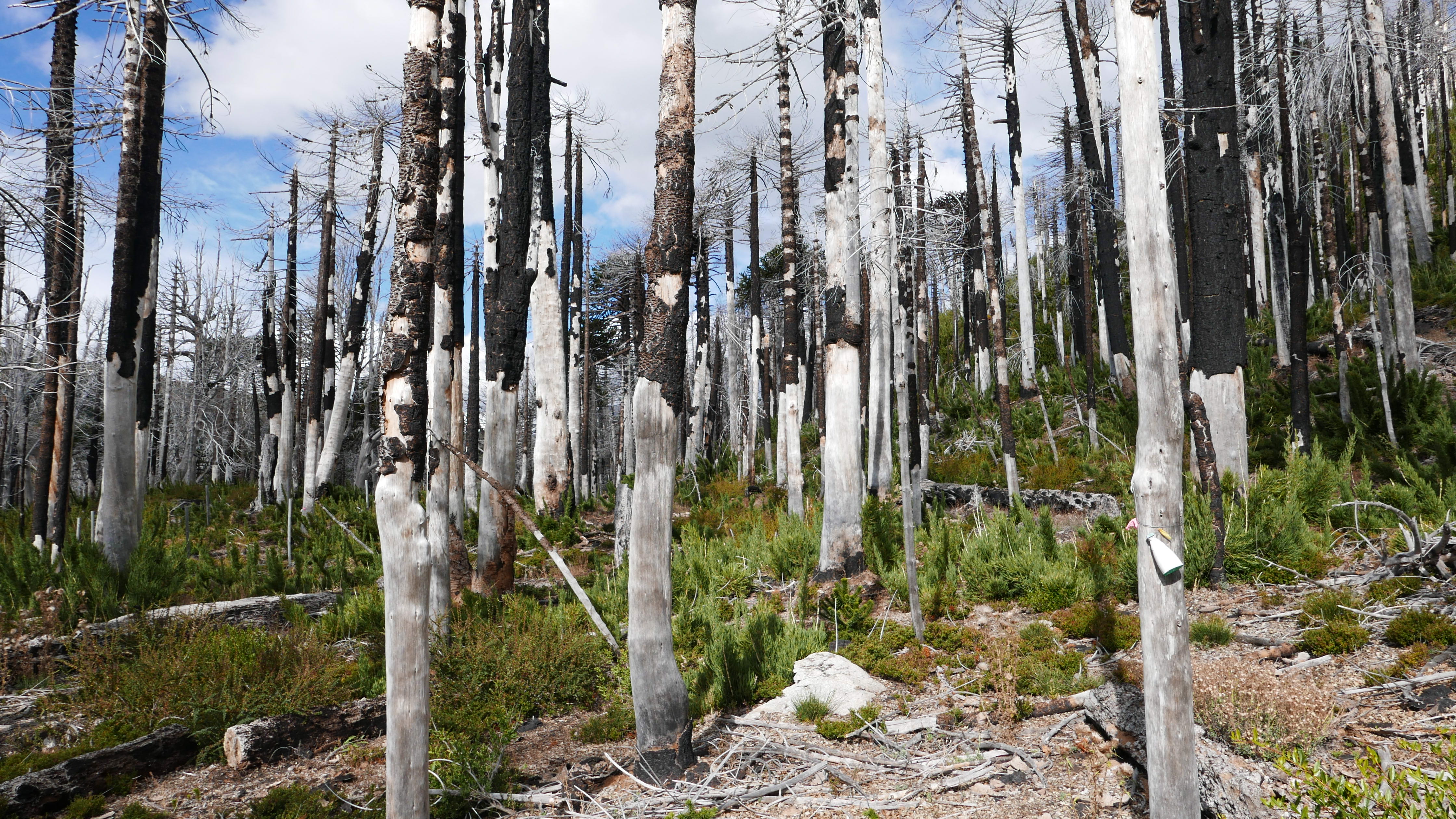
SCL: When you see only white trees at the top, it means that something happened here and that it has taken about a generation or two to start recovering. Imagine if such a large forest fire happened again. Not only would it cause damage to the ecosystem, but it would also cause spiritual and cultural damage to our people. How do we plan to create training opportunities? For example, even something as basic as having people trained to protect these places. I don't know if I would call them park rangers, but the idea is something more than just those assigned to be caretakers of an area.
We also need to train local brigades to take quick action in these areas during fire seasons, when response time is extremely important. An hour's difference in response time can be the difference between a catastrophe and a simple isolated incident. So, those are the challenges. The fundamental idea is also to restore the ecosystem of many areas that are currently devastated by illegal deforestation in many communities. Before 1900, Wallmapu was a jungle. Reforestation is essential and something we are starting to work on both in Panguipulli and in our area.

Mural near Trawupeyum Intercultural Village in Curarrehue, Chile. Jennifer Gabrys, 2023.
Intermediate Disturbance: The myth of Lalen Kuze
Pamela Iglesias
One day, a girl was washing mote in the river,
a man came and stole her;
he took her to his land and married her.
They say he told her, “I'm going to Puelmapu,
when I return, all this wool must be woven.”
The man left and the girl was left crying
she didn't know how to weave! She stayed crying by the hearth
and then the ancient fire spoke to her:
“Don't be so sad, I'll call the grandmother spider to help you.”
A little while later, the grandmother spider appeared, climbing down to the fire, and said to the girl:
“You have to do it like me. Watch me and you'll learn how to weave.”
So the days went by,
and every night the grandmother spider came to help the girl
and together they finished the weaving.


